Now that Storm Season is underway in Ontario, I felt it was time to write another article on the subject. This one will be a little different compared to the Silo articles I have written in the past. It will be about those golden moments when both the storm chaser and the breathtaking cloud structure will be in the same scene together.
There are a lot of excellent storm chasers in our province who have an absolute love for weather.
I could write a entire paragraph with just the names of those in our province alone. Whether it be photographing, forecasting from home, or reporting the storms, the chasers share the same dedication and passion. They all have different qualities that make them enjoyable to be around and to share the experiences as a group. In this collection, you will see a series of photos showing the storm chasers in action across various parts of the province. I only wish I had more photos of everyone in the storm chasing community.
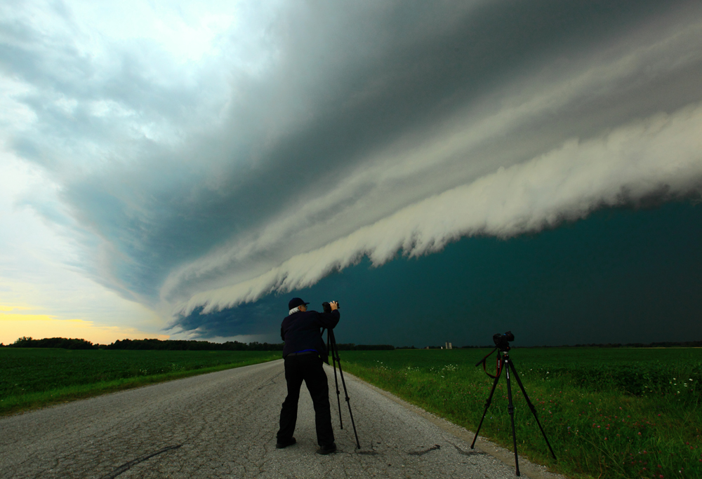
This photo is of a man I have chased with for over 19 years now. He is my dad, Brian Chapman. He and I have worked along side each other for many years, tracking down numerous lightning storms, several tornadoes and epic squall lines like that which is visible in this photograph. This storm was taken on August 2, 2016, south of Goderich, Ontario. You can see the layering of the gust front shelf cloud as it approached our location. The storm also had golf-ball sized hail in it with damaging winds. There were unconfirmed reports of a tornado wrapped in rain and hail with this storm, just north of our location, according to fellow chasers in the area.
Brian and I chased for 9 years without portable radar, using radar at home. I would animate it in my head and figure out where we had to be. Also, while out there, we would use AM radio to gage how intense the storms were as well as their general location based on the intensity of the static on the station. We are both happy to have portable information now, but when that fails every now and then, we are both quite comfortable using only visual cues.
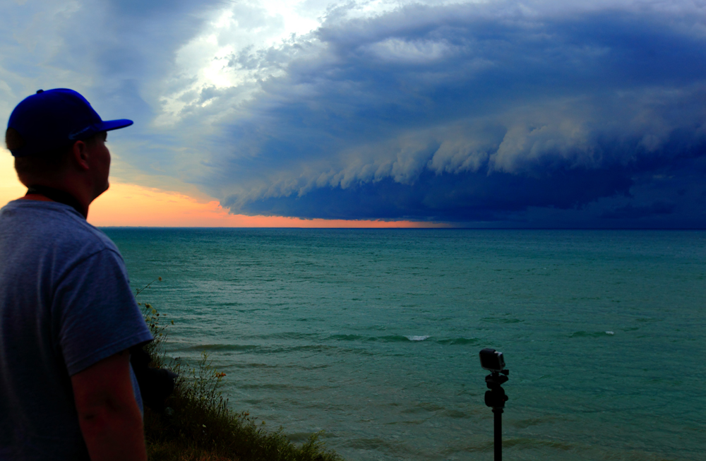
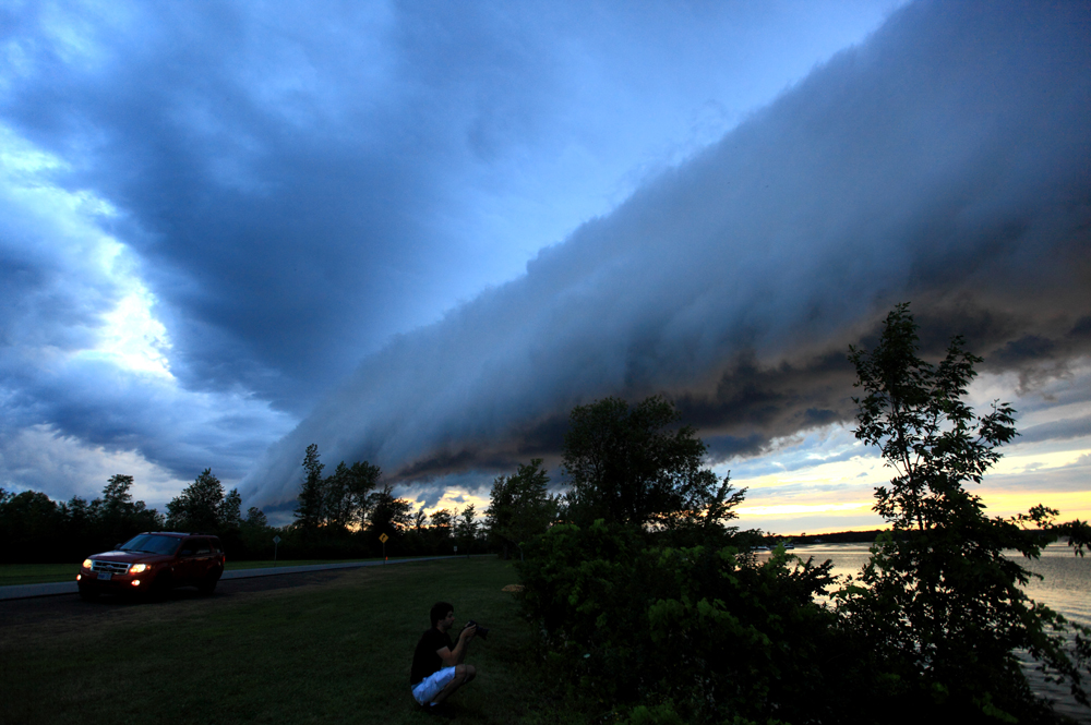
It is hard to believe that Spencer Sills and I used to live 10 kilometres apart when we were kids. We were both crazy about the weather. I even went to church across the road from where he lived, yet we didn’t know each other until connecting on social media years later when our friendship grew into an unbreakable bond. He and I both used to chase on our bicycles when we were younger, before we could drive, if no adult was able to take us out. That definitely led to some quick peddling back home at times.
We both have a background where instinct is a big part of chasing. We feel comfortable not having radar information. Spencer is an amazing forecaster and helped get me started in the world of forecasting. He is one of my all-time favorite photographers whether it is storm related or other various subjects. In this particular photo, you can see the huge shelf cloud coming across Lake Huron, just north of Grand Bend.
It was roughly 10 minutes after this, that we had an experience of a lifetime.
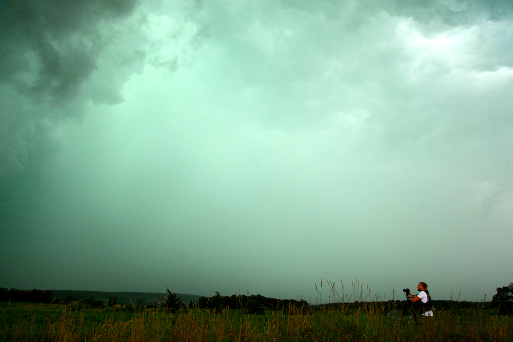
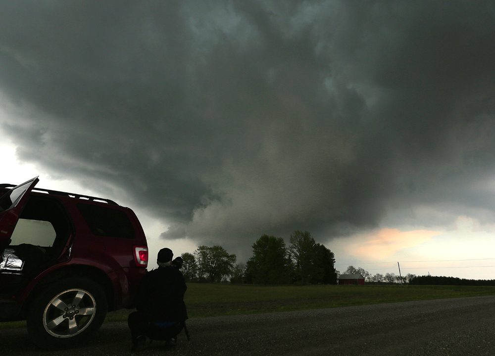
In the photo above, you see that we have a very large and heavy rain/hail core coming at us. Not quite as green as in the previous photo but this storm was dropping hail around quarter-size. It was a long chase day, something Kyle Robertson and I are used to doing.
Both Kyle, my dad and I have something in common in this respect — that is, we will literally chase anywhere in any type of terrain for as long as necessary. We are comfortable no matter how heavy the trees are for blocking visibility because we always believe we will get that opening when we need it most. To give you an idea, we have all chased in the Bancroft area, north of Georgian Bay towards Sudbury and even on the north end of Manitoulin Island.
In this particular chase, we started in the Listowel area after leaving the Niagara region, ending up in the Owen Sound area before getting something to eat in Collingwood. As we were on our way home, a line of storms fired up on Lake Erie, so we headed to Port Maitland and then across to Crystal Beach until 3:00 a.m. in the morning. This is typically how Kyle and I both are. We have a confidence in each other for getting us to the target area and that we will get amazing photos when we arrive. Kyle is one of the most determined, driven people that I know. He has a superb knowledge on the history of tornadoes in Ontario and is an excellent photographer.
I don’t have many photos of myself while storm chasing.
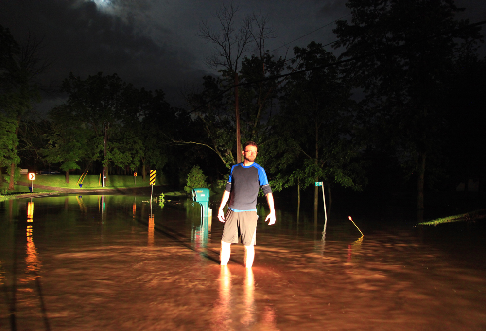
I am often busy running from camera to camera. On June 12, 2014, close to Fonthill and travelling towards St. Catharines, there was a tornado warned storm that went through this area. It put on a tremendous lightning show along with very heavy rain as you can see on this roadway near the town of Rockway. My dad and I tracked this storm around midnight. Fortunately, it did not develop a tornado. Tornadoes are bad at anytime but when they hit at night, it can be a lot worse due to the fact that people are sleeping. It is a good thing that Ontario is not prone to having many tornadoes at night. It is still important to listen to all warnings but generally we have not had any really major tornadoes hit at night in recent years.
The photo above is another look at my dad doing what he loves to do which is videotaping rotating wall-clouds. He used the vehicle in this situation to shield him and the camera from the winds. It helps to eliminate camera shake when hit by gusty winds. This rotating wall cloud, like most of them in the northern hemisphere, was rotating counter-clockwise. It was shortly after this that it tightened up into a nice cylinder shape before dissipating and eventually elevating over Lake Erie.
My brother, Eric Chapman, doesn’t get to storm chase often but when he does, we often get to see some interesting cloud structure like this one.
This was a large outflow boundary that first developed near Grimsby, Ontario, where it was still attached to the storm. We continued to track this storm all the way to Niagara Falls before following it south down the Niagara River to Fort Erie. At this point it had completely detached itself from the core of the storm. This is often when storms form a roll cloud but this one didn’t quite have those characteristics. I call these “rolling shelf clouds” because they have features of both. Generally, you can see the rolling effect in the bottom part of it, and at the same time it has a shelf-like feature above, but with no rain-core or storm attached to it.
A little change of pace in the photo above.
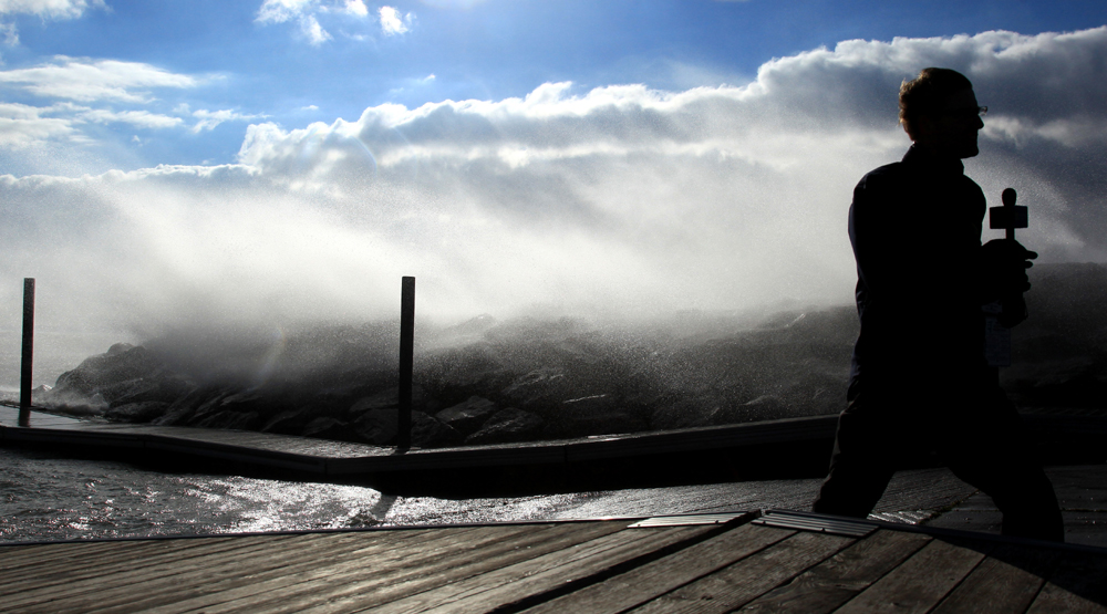
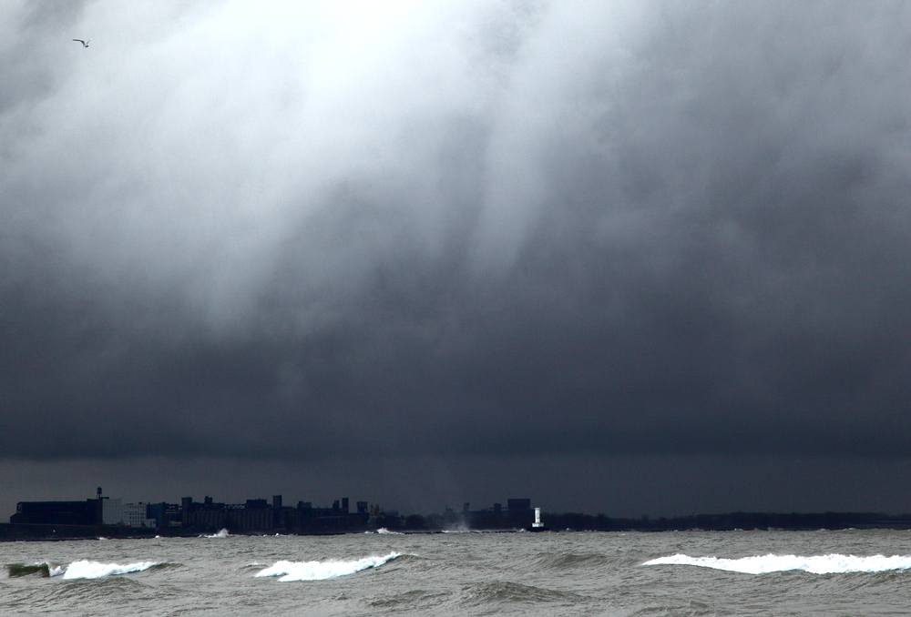
My friend, Mark Robinson, also known as one of the Storm Hunters on The Weather Network, has a passion for extreme weather. He has chased storms like Hurricane Katrina, as well as the largest tornado in recorded history in the El Reno area, on May 31, 2013, that measured as much as 5.2 kilometres in width. That all said, he is very much dedicated to what we get here in Ontario. From storm chasing in the summer and winter, to hunting down the big autumn wind storms, like this one, that seem to hit at least once every November. This particular photo was taken in Crystal Beach, Ontario. A hot spot for big waves and strong winds during the fall and spring.
A fellow storm chaser and friend of mine, Dave Patrick, a.k.a. “Tornado Dave“, is one of my all-time favorite chasers. After growing up in Grey County and chasing with my dad for around 5 years, Dave was the first storm chaser in Ontario that I learned about outside of our own team. It was when I came across his website, that I realized there were other dedicated chasers in our province.
It was really neat to study his site for years and then to finally meet him in March of 2012.
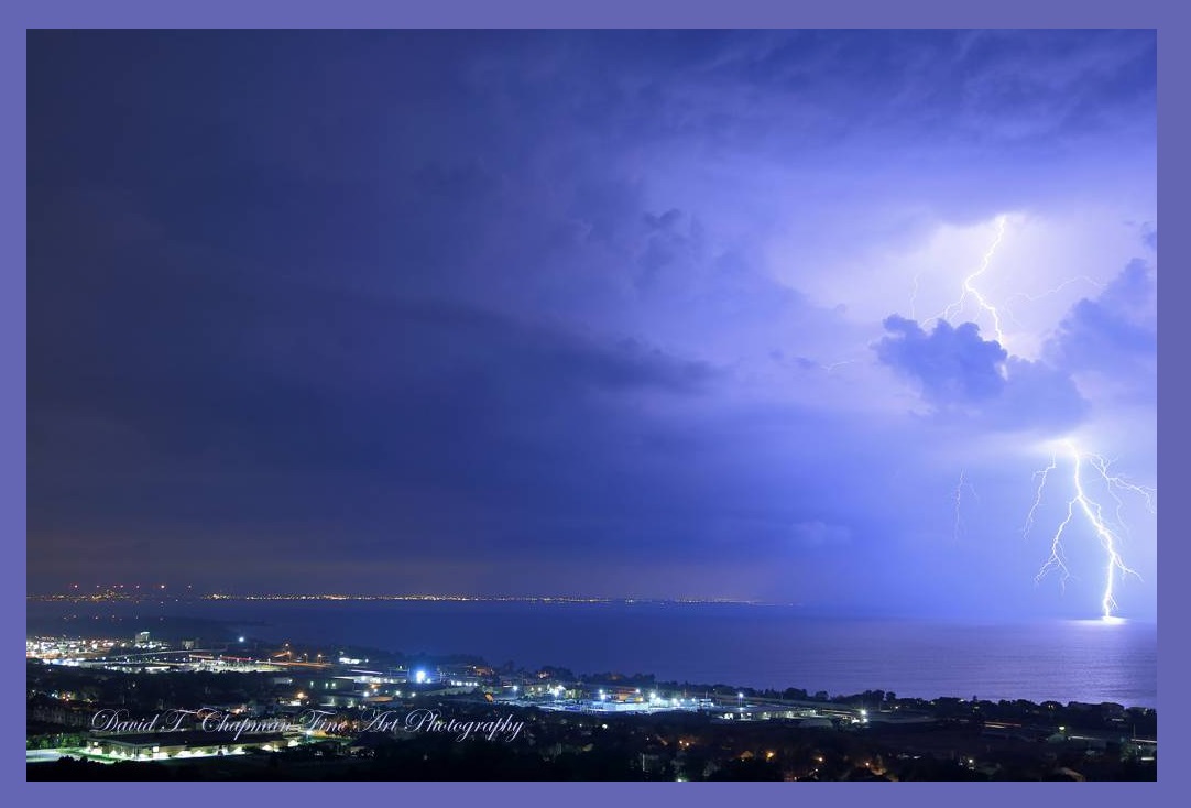
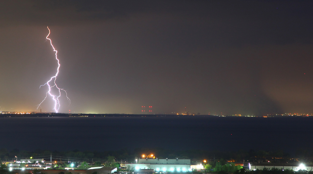
It was in August, 2013, after both he and our team were tracking the same tornado east of Arthur, that our friendship and bond grew. Like many of the chasers I have mentioned, Dave and I could talk for hours about storms, tornadoes and whatever else was in the sky. I have learned a lot from him for which I am truly grateful. He truly has a gift of reading both the sky in the daytime as well as at night. Although I don’t have any photos of him, I chose a photo of lightning because of the force of a person that he is and the dedication he demonstrates when documenting weather.
The main focus for our team this year will be anything that forms a super cell tornado or waterspout.
Kyle, Brian and myself have documented so much in the way of thunderstorm activity now, that we only really need to work on adding to our already good-sized tornado and waterspout collection. It is also our true passion to try to figure out the puzzle of where the next major event could happen and to be there when it does. Waterspouts are easier in that respect, but it still requires a lot of work to make sure you are in the right location at the right time. As for tornadoes, our province averages about 12.5 per year or as I like to call it, 12 tornadoes and a funnel cloud. Many of them are short lived and can be quite sporadic with respect to where they form. So when you start to break it all down, to get the timing just right is more like an art form than anything else.
We never stop working on ways to improve the methods of forecasting and documentation. The waterspout you see in this photograph was taken on Halloween, 2017, on the most eastern part of Lake Erie, south of Fort Erie, looking east towards the city of Buffalo, New York. It was by far one of the best Halloweens I have ever had. I saw 9 waterspouts, 17 funnels and 2 spray rings that day. It was amazing to witness that over a span of only 2 hours.
For the 2020 storm chasing season, I will only be out for supercell tornadoes, waterspouts, sprites, blue jets and local lightning work.
I have every other aspect of thunderstorms that I need ranging from the small to the big to the unusual. I have combined all of my years of data and have created a powerful, educational and entertaining series of programs that I present in person in front of crowds and which are now also available through online virtual presentations. For the Silo, David. T. Chapman.
To learn more about Kyle Robertson, Spencer Stills and some of the storm chasers mentioned in this article, contact David T. Chapman at his link above.