

Part One
“I have seen many storms in my life. Most storms have caught me by surprise, so I had to learn very quickly to look further and understand that I am not capable of controlling the weather, to exercise the art of patience and to respect the fury of nature”
My name is Spencer Sills, and I am a storm chaser, some of you may remember a few years back reading about my good friend David Chapman and myself in this very newspaper and our journeys on the road to capture Nature’s fury through our lenses. Not much has changed since then, we are both still on the hunt for the elusive supercell and what fury may come with it.
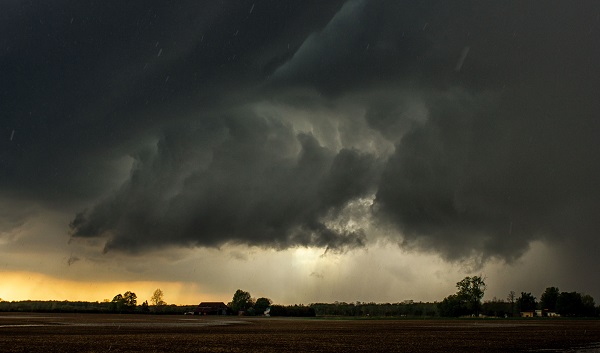
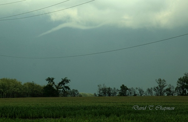
In 2014 my overall goal to capture a tornado in Ontario was once again successful, on July 7th I teamed with Scott Burlovich of Restless Skies photography and his chase partner Harry for the day and we set out to capture some pulse storms that were flaring up in the afternoon, most of these cells were just rain makers but on the way back to my home I had noticed a wall cloud that was lit up by the sun, we pulled off to the side of the road directly South of Norwich and briefly documented a EF0 tornado in a farmers field before it lifted causing no damage since it was in a dry field. This was my only tornado of the year, in a busy season. I did however get to document several gorgeous storm cells throughout the year, including several beautiful stacked shelf clouds and a great Wall cloud early in the season that brought golf ball sized hail to the area.
In 2015 I hope to achieve a few goals, one of which is to capture yet another tornado in this province, hopefully just like 2014 in an open field away from any properties. I also have set my sights on some goals with lightning and capturing it in a different perspective, I can’t go into much detail but it will be a stunning sight if I can achieve it. As far as how I believe the season will go, I do believe it will be a slow start, April and May will bring the return of storms, but I don’t expect anything too severe until June and July once the humidity and warmth really have a chance to build in. I do however once again stress to leave chasing to the pros, if you’re interested in storm spotting, please look into Canwarn, the more spotters in the province the quicker warnings can be issued thanks to verified ground reports.
I will be working alongside another photographer and storm spotter this year, Scott Burlovich of Restless Skies, please feel free to check out his amazing work at restless-skies.com and give him a follow on twitter @restless_skies , you can also follow my journey for the year at Lightningfastphotography.com or on twitter @spencersills. I also want to send my best wishes to David Chapman for a great 2015, and as always look forward to meeting him in the field under the Meso, stay tuned for more updates and stay sky aware this summer!
Part Two
Another winter has come and gone, although perhaps slower than a lot of us would like. At least this means that the storm season is once again upon us in Ontario. As usual, Brian Chapman and I, a father and son chase team, will be back out on the roads looking for the best images of lightning and searching for Ontario’s tornadic super cells.
We will also be in close communication with our good friends and fellow chasers, Spencer Sills and Scott Burlovich, as we tend to share a lot of information about the biggest potential storms before we go chasing. You’ll notice when you look through their photography collections that they are a couple of the best for chasing down the biggest storms in our province.
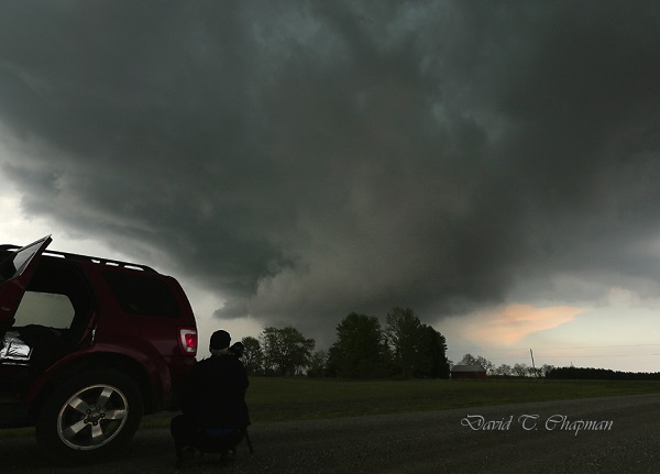
You might be curious on what we do when it comes to chasing the actual storm. Brian’s job is to be the driver. This is his first priority. Once we are parked and in a safe but photographic position for the storm, he is our main videographer. As for myself, I choose where I think the biggest storm will form from looking at weather models that meteorologists use as well as talking to fellow storm chasers in the area. I am also the main photographer. I do some video work and navigate us to the most photogenic side of the storm. This is usually right next to the most dangerous part of the storm but still in the safest position possible.
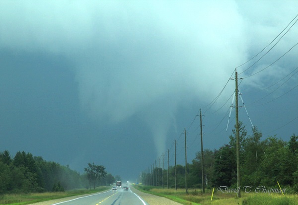
In the past 2 years, our team has seen and recorded a number of funnel clouds, 2 confirmed tornadoes and 4 waterspouts. One of the tornadoes was near Arthur, Ontario on August 7, 2013 and the landspout tornado was near Listowel, Ontario on May 14th 2014. The Arthur tornado was a really great one to document. It lasted for close to 15 minutes and we were able to see it from start to finish. The best part about it was the fact that no one was injured and it caused very little damage. Those are the kinds of tornadoes we love to see because they allow you to enjoy the pure power and beauty that they possess but without injuries or major destruction.
Another thing that was interesting with the tornado that hit near Arthur was the fact that it tried to form a second tornado at the same time the first one was on the ground. If that funnel had reached the ground, it would have been called a satellite tornado. They are typically smaller and weaker but not always. In Pilger, Nebraska in 2014, two EF-4’s were on the ground at the same time. Sadly they hit a town, killing 5 people and injuring 19. Those are the days I dread as a chaser and hope I never see first hand. As for the second funnel near Arthur, it didn’t quite have the energy to make it the rest of the way to the ground. This probably wasn’t such a bad thing with so many people focusing on the main, larger tornado just to its north.
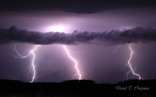
Fortunately, a lot of Ontario’s tornadoes hit open areas that cause little to no damage. There have been some exceptions, as the tornadoes that hit both Durham, Ontario on August 20, 2009 and Goderich on August 21, 2011 showed, both killing one person in each of them. That is why many storm chasers as well as dedicated weather enthusiasts in our province have a direct line to Environment Canada that allows us to contact them when we see threatening weather approaching the area we are in. It can help Environment Canada confirm what they are seeing on radar so that they can issue the proper watches and warnings accordingly. Refer to Spencer Sills’ Part One above for more details on how you can become a spotter. Lightning will also be a big focus for our team this year. We continue to work to get lightning photos as close as possible in order to capture the positive leaders that come up to meet the main negative current coming down from the cloud. The leaders can come from the ground, hydro poles, houses and even people.
Although this may be risky and dangerous, we have worked out ways to minimize the risk to us. We stay in the car when lightning is close with the windows up. We also won’t park under a tree, not so much from the fear of a direct lightning strike but in case lightning hits and splits the tree causing it to fall on the vehicle. I remember seeing one like that when I was young and it has had an everlasting impression on me. One of the first big wind storms I chased along Lake Erie on November 1, 2013 knocked down a tree onto a woman‘s car and unfortunately she was in it and was killed. So debris is always a concern and something to be very aware of when it comes to storm chasing.
You can follow our storm chasing throughout the year on our social media pages. https://twitter.com/DTChapmanPics https://www.facebook.com/pages/David-T-Chapman/173134962767601?fref=ts https://twitter.com/WeatherHunters
Leave a Reply
You must be logged in to post a comment.